Every four years since 2009, MVRPC has coordinated multiple trail-managing agencies across the Miami Valley to conduct a regional trail user survey. Efforts in 2009, 2013, 2017 and 2021 have fulfilled objectives in the Comprehensive Local-Regional Bikeways Plan and the Miami Valley Bike Plan Update 2015.
The surveys, counts, and reports represent the combined efforts and commitments of multiple trail managing agencies and the countless volunteer hours they are able to bring to bear for this project.
With each iteration of the survey, the effort has evolved to include more communities, expanded questions, and new technologies. These changes reflect the increased reach and connectivity of the Miami Valley Trails themselves, as well as the growing partnership and collaboration of the many agencies that manage parts of the system.
Despite the development of the survey project, the core findings of the surveys are comparable from year to year and serve as a baseline for understanding how, when, and by whom our Miami Valley Trails are being experienced.
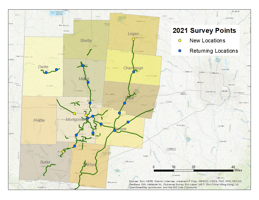
The 2021 survey was the most extensive survey undertaken to date. Survey locations were stationed in nine counties along the Miami Valley Trails (see map). From Middletown to Cedarville, from Greenville to Bellefontaine project volunteers collected 1,715 surveys and counted over 12,000 trail users.
Additional data from the 2021 survey is available upon request. Contact Rebecca Carr, Active Transportation and Environment Planner, at [email protected], Manager of Environmental Planning, regarding this and past trail user survey projects.
The following agencies and organizations provided volunteers and person-hours to the Miami Valley Trail User Survey project for 2021:
- Centerville-Washington Park District
- Clark County Park District
- Darke County Park District
- Five Rivers MetroParks
- Greene County Parks & Trails
- Metroparks of Butler County
- Miami County Park District
- Miami Conservancy District
- Simon Kenton Pathfinders
- Bike Miami Valley
- Bike Piqua
Survey Reports
The following Miami Valley Trail User Survey Reports are available for review:
| Reports | Appendices |
|---|---|
| 2021 Report | |
| 2017 Report | 2017 Appendices |
| 2013 Report | 2013 Appendices |
| 2009 Report | 2009 Appendices |
Bicycle Counting Program
A complementary effort at MVRPC is the Bicycle Counting Program. Also in coordination with many trail-managing agencies, this program seeks to aggregate automated trail user counts and short-term bike counts to measure the use of bicycling across the Region.
Tale of the Trails
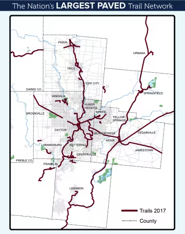
The Miami Valley Region boasts the Nation’s Largest Paved Trail Network, offering many benefits to the people that utilize those trails. For more information, visit MiamiValleyTrails.org.
In coordination with multiple trail-managing agencies across the Miami Valley Region, MVRPC has conducted a Trail User Survey and Count every four years since 2009. With each iteration, the effort has evolved to include more communities, expanded questions, and new technologies. These changes reflect the increased reach and connectivity of the trails, as well as the growing partnership and collaboration of the many agencies that manage parts of the system.
By the Numbers
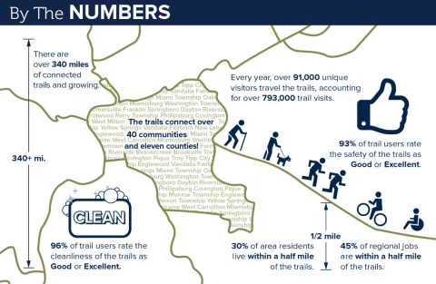
- There are 340 miles of connected trails, and that number grows each year.
- The trail connects over 40 Communities in eleven counties.
- Every year, over 91,000 unique visitors travel the trails, accounting for over 793,000 annual trail visits.
- 96% of trail users rate the cleanliness of the trails as good or excellent.
- 93% of trail users rate the safety and security of the trails as good or excellent.
- 30% of area residents live within a ½ mile of the trails network, and 45% of regional jobs ae within a half mile of the trails.
Who uses the trail?
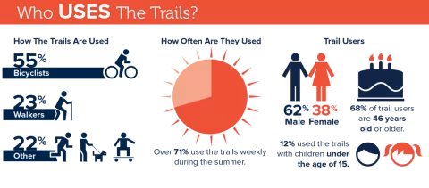
- 55% Bicyclists, 23% Walkers, 22% Other (Jogging/Running, Walking Pets, Roller Blade/Skating, X-Country Skiing).
- Over 71% use the trails weekly during the summer.
- Trail users are 62% Male, 38% Female.
- 68% Trail users are 46 years old or older.
- 12% used the trail with children under the age of 15.
Health Benefits of the trail
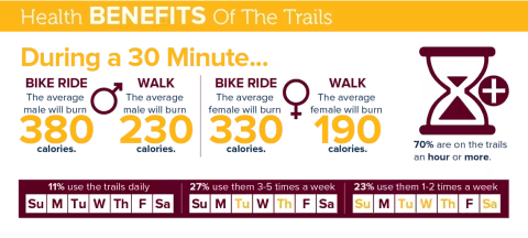
- 11% use the trails daily, 27% use them 3-5 times per week, 23% use them 1-2 times per week.
- 70% are on the trail an hour or more.
During a thirty minute bike ride…
- The average male will burn 380 calories.
- The average female will burn 330 calories.
- Depending on your weight, you can burn between 215-500 calories during a 30-minute bike ride.
During a thirty minute walk…
- The average male will burn 230 calories.
- The average female will burn 190 calories.
Calorie data for bicycling and walking comes from healthstatus.com/perl/calculator.cgi.
Economic Benefits of the trail
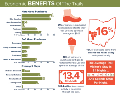
- 16% of trail users are from outside the Miami Valley and spend locally.
- The trails generate $13.4 million in economic activity is generated through the trails.
- 71% of trail users purchased hard goods related to their trail use and spent an average of $507.
- 48% of trail users purchased soft goods related to their trail use and spent an average of $13.
- The average trail visitor’s stay is 3.1 nights and spends $108 per night.


Ohio’s Miami Valley Region provides over 340 miles of paved, multi-use trails. Stretching across county lines, these trails connect schools, parks, historic landmarks, and area attractions. Path users travel through meadows, scenic countryside, forested areas, and city centers. Our great system of trails enhances both the wellness and quality of life of Miami Valley residents and visitors. All trails are free and open to the public every day of the year, from dawn till dusk.
For updates about trail conditions, visit miamivalleytrails.org.
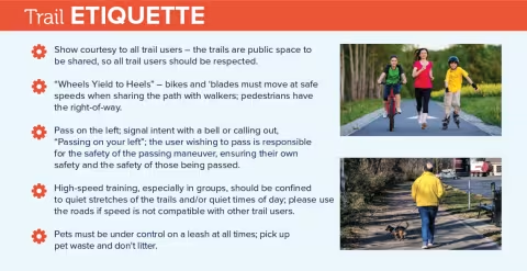
Trail Etiquette
- Show courtesy to all trail users – the trails are public space to be shared, so all trail users should be respected.
- “Wheels Yield to Heels” – bikes and ‘blades must move at safe speeds when sharing the path with walkers; pedestrians have the right-of-way.
- Pass on the left; signal intent with a bell or calling out, “Passing on your left”; the user wishing to pass is responsible for the safety of the passing maneuver, ensuring their own safety and the safety of those being passed.
- High-speed training, especially in groups, should be confined to quiet stretches of the trails and/or quiet times of day; please use the roads if speed is not compatible with other trail users.
- Pets must be under control on a leash at all times; pick up pet waste and don't litter.
Drive Your BIKE
- In Ohio, a bicycle is considered a vehicle and a bicyclist is deemed a driver. Obey all traffic laws.
- When riding a bicycle at night, it's required to use a good headlight, a rear red light, colorless (white) front reflector, rear red reflector, and either reflective rims or spoke reflectors.
- Ride to the right whenever practicable; take the lane when there are hazards present or to change lanes.
- Use hand signals to indicate turns, lane changes, and stops. Signal well ahead of your move and glance over your shoulder to let motorists know you want to move over.
- Always ride with traffic – don’t be a wrong-way driver.